
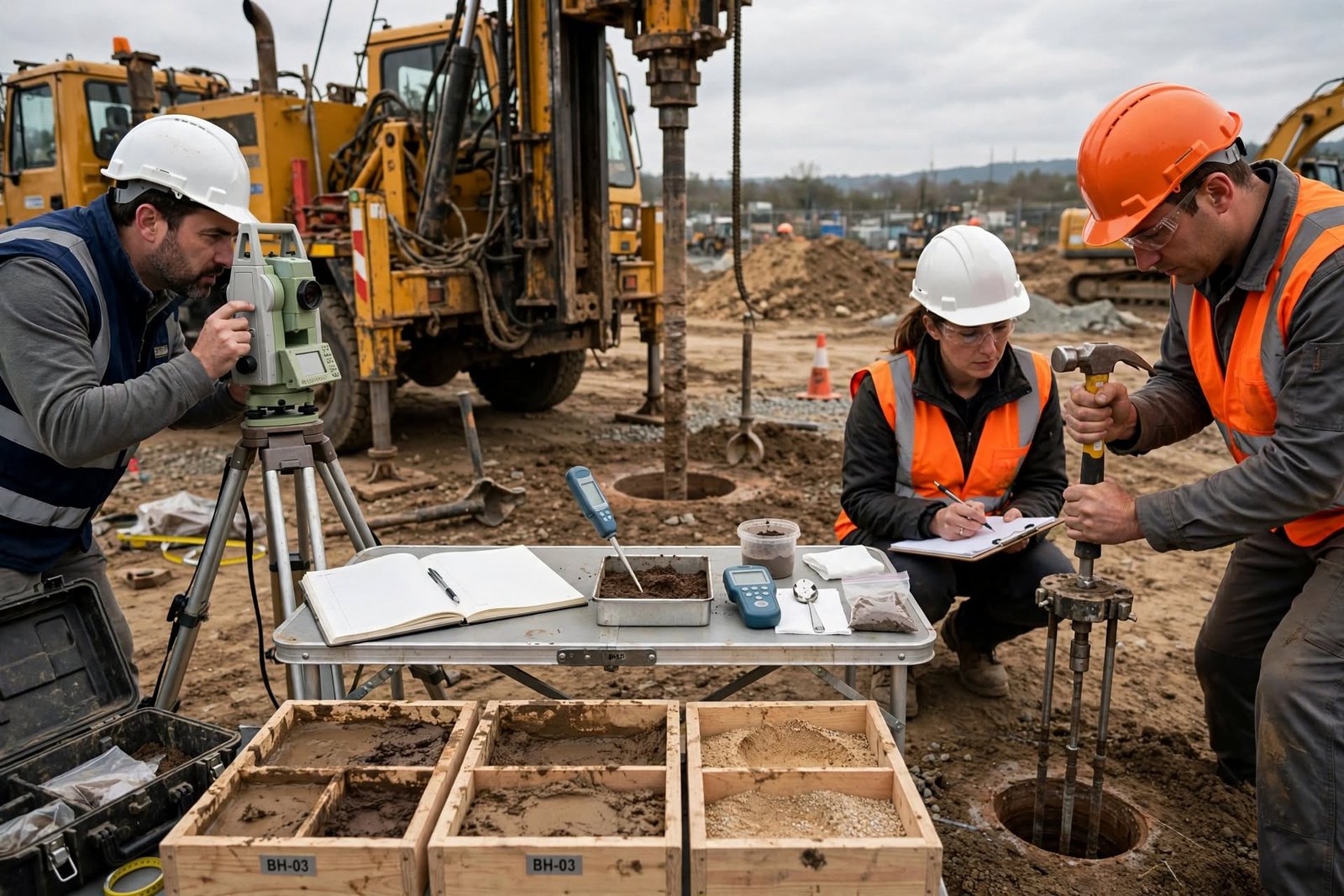
1. Introduction — Why the Ground Decides Everything
Every structure — a two-storey house, a multi-storey apartment block, a factory shed, or a highway bridge — ultimately transfers its entire weight to the ground beneath it. If the ground cannot safely carry that load, no amount of high-grade concrete or premium steel will prevent failure. This is why site survey and soil investigation are the true starting points of every successful construction project.
Yet in Indian construction practice, these two activities are the most frequently skipped, hurried, or under-budgeted. Homeowners often build on "what the neighbour's foundation did," developers sometimes begin excavation before a single borehole has been drilled, and contractors regularly proceed on assumptions rather than data. The result is a pattern of distress we see repeatedly: differential settlement, cracked walls, tilted floors, seepage, and in extreme cases, structural collapse.
This comprehensive guide explains, in plain engineering language, what a site survey and soil investigation actually involve, how they are carried out in India, what the results mean, and how they influence the design and cost of foundations. Whether you are a first-time homeowner, an architect, a structural designer, or a contractor, understanding these fundamentals will protect your project and your investment.
2. What Is a Site Survey?
A site survey is the systematic collection of physical, topographic, legal, and environmental information about a plot of land before design begins. It establishes the factual reality of the site — as opposed to what the drawings or the seller claim.
A proper site survey answers questions such as:
- What is the exact shape, size, and boundary of the plot?
- What are the existing ground levels, and how much cut-and-fill will be needed?
- Are there existing structures, trees, wells, or underground utilities?
- Where does rainwater flow, and does the site flood?
- What is the legal status — ownership, encumbrances, easements, and access rights?
- What are the local bye-laws regarding setbacks, height, FAR/FSI, and coverage?
A site survey is not merely a formality. It directly determines how the building will sit on the land, where the foundation will go, how drainage will work, and whether the project is even feasible within the client's budget and the municipal regulations.
3. Types of Site Surveys
3.1 Topographic Survey
A topographic survey records the natural and man-made features of the land, including ground levels, contours, slopes, and existing structures. It is usually performed using a total station, dumpy level, or drone survey. The output is a contour map that the architect and structural engineer use to plan levels, drainage, and cut-and-fill volumes.
3.2 Boundary and Cadastral Survey
This confirms the legal boundaries of the plot against revenue records (in India, typically the 7/12 extract, khata, or khasra records depending on the state). Boundary disputes are extremely common, and a licensed surveyor's confirmation prevents future litigation.
3.3 Utility and Subsurface Survey
Before excavation, it is critical to know if water pipelines, electrical cables, sewer lines, or communication ducts run under the site. Ground-penetrating radar (GPR) and utility detection surveys are increasingly used to avoid damaging existing services.
3.4 Drainage and Flood Risk Assessment
Assessment of how stormwater flows across and away from the site, and whether the plot lies in a flood-prone zone. This determines plinth height, retaining structures, and drainage design.
3.5 Environmental and Geotechnical Screening
An initial walk-over to identify visible signs of poor ground — cracks in nearby buildings, sloped land, old fill areas, abandoned wells, high water table indicators, or signs of previous excavation.
3.6 Legal and Regulatory Survey
Verification of title, encumbrances, easements, road access, and any restrictions imposed by local development authorities. This is as important as the physical survey for a safe and legally compliant project.
4. What Is Soil Investigation?
Soil investigation (also called geotechnical investigation) is the process of determining the physical and engineering properties of the soil and rock beneath a site, to a depth sufficient to influence the design and construction of foundations. It is the single most important input for foundation design.
Soil investigation seeks to answer three fundamental questions:
- What is the soil made of? (Its classification, layering, and composition.)
- How strong is it? (Its shear strength, bearing capacity, and settlement characteristics.)
- How does it behave with water and time? (Its permeability, expansion potential, and consolidation behavior.)
Essential Truth: A foundation cannot be designed safely without knowing the bearing capacity and settlement characteristics of the soil beneath it. Every rupee spent on proper soil investigation saves many rupees on unnecessary over-design — and protects against catastrophic under-design.
5. Stages of a Soil Investigation Programme
5.1 Desk Study and Reconnaissance
Review of available geological maps, previous investigation reports (if any), nearby borehole data, and a physical site walk-over to observe signs of instability, fill areas, or previous construction activity.
5.2 Planning the Investigation
Deciding the number, spacing, and depth of boreholes based on the size and type of the proposed structure. As a general Indian rule of thumb:
- Small residential building (up to G+2): at least 2–3 boreholes, 5–8 m deep
- Multi-storey apartment or commercial building: 4+ boreholes spaced 15–25 m apart, depth 15–30 m depending on loads
- Industrial sheds and warehouses: boreholes at column locations
- Bridges and heavy infrastructure: boreholes at every pier and abutment, depth often exceeding 30 m
5.3 Field Investigation
Boreholes are drilled using augers, rotary rigs, or percussion rigs. Standard Penetration Tests (SPT) are performed at regular intervals, and undisturbed samples are collected for laboratory testing.
5.4 Laboratory Testing
Collected samples are tested for index properties, shear strength, consolidation, and chemical composition.
5.5 Analysis and Reporting
All field and lab data are compiled into a geotechnical report with a recommended safe bearing capacity, expected settlement, and foundation recommendations.
6. Field Tests — SPT, DCPT, and Plate Load
6.1 Standard Penetration Test (SPT)
The most widely used field test in India, governed by IS 2131. A standard split-spoon sampler is driven into the soil by a 63.5 kg hammer falling 750 mm. The number of blows required to drive the sampler 300 mm is the "N-value." This N-value correlates directly with soil density and bearing capacity.
6.2 Dynamic Cone Penetration Test (DCPT)
A lighter, faster alternative used for shallow depths, especially in road and pavement design. Gives an indicative picture of stratification and relative density.
6.3 Plate Load Test
A steel plate is loaded on the ground and settlement is measured. This provides a direct measurement of in-situ bearing capacity and settlement behavior. Governed by IS 1888, it is often performed to confirm SPT-based predictions for critical structures.
6.4 Static Cone Penetration Test (SCPT)
A cone is pushed into the ground at a constant rate, and tip resistance and sleeve friction are recorded. Excellent for soft and layered soils, and increasingly used for larger projects.
6.5 Field Vane Shear Test
Used in soft clays to determine undrained shear strength. Standard for infrastructure projects in coastal and alluvial regions.
7. Laboratory Tests on Soil Samples
Laboratory tests provide the detailed parameters required for accurate foundation design. Common tests include:
| Test | Purpose | Relevant IS Code |
|---|---|---|
| Grain Size Distribution (Sieve & Hydrometer) | Classify soil as gravel, sand, silt, or clay | IS 2720 Part 4 |
| Atterberg Limits | Determine plasticity and consistency of clays | IS 2720 Part 5 |
| Specific Gravity | Basic property used in void ratio calculation | IS 2720 Part 3 |
| Natural Moisture Content | Indicates current field condition | IS 2720 Part 2 |
| Direct Shear Test | Determine cohesion (c) and angle of internal friction (φ) | IS 2720 Part 13 |
| Triaxial Compression Test | Determine shear strength parameters under controlled conditions | IS 2720 Part 11 & 12 |
| Unconfined Compression Test | Undrained shear strength of cohesive soils | IS 2720 Part 10 |
| Consolidation Test | Predict long-term settlement | IS 2720 Part 15 |
| Proctor Compaction Test | Determine maximum dry density and optimum moisture for fill | IS 2720 Part 7 & 8 |
| Chemical Analysis | Sulphate, chloride, and pH for durability assessment | IS 2720 Part 26 & 27 |
8. Determining Safe Bearing Capacity
Safe Bearing Capacity (SBC) is the maximum pressure that a foundation can safely transmit to the soil without causing shear failure or excessive settlement. It is the single number from which every footing dimension is derived.
SBC is typically calculated from SPT N-values using established correlations (e.g., the Teng, Meyerhof, or IS 6403 methods), and refined using laboratory shear strength parameters and plate load test data. A geotechnical engineer evaluates:
- Ultimate Bearing Capacity: The pressure at which the soil fails in shear
- Allowable Bearing Pressure: The pressure which keeps settlement within permissible limits (typically 25–40 mm for isolated footings, 50–75 mm for raft foundations)
- Net Safe Bearing Capacity: Allowable pressure after deducting overburden pressure at foundation depth
Typical SBC values for guidance (actual values from investigation must always be used):
- Very soft clay: less than 50 kN/m²
- Loose sand: 50–100 kN/m²
- Medium dense sand: 100–250 kN/m²
- Dense sand or stiff clay: 250–500 kN/m²
- Hard rock (weathered): 500–1500 kN/m²
- Sound rock: 1500–4500 kN/m²
9. How the Report Shapes Foundation Design
The geotechnical report is not the end product — it is the beginning of informed design. It directly drives the following decisions:
- Foundation Type: Whether isolated footings, strip footings, raft, or piles are appropriate. Poor soil with high loads typically forces a pile foundation, dramatically increasing project cost.
- Foundation Depth: Must reach strata with adequate bearing capacity and be below the zone of seasonal moisture change (typically 1.5–2.0 m in India) and below the active zone of expansive clays.
- Footing Sizes: Larger footings are required where SBC is low, consuming more concrete and steel.
- Reinforcement Detailing: Settlement-prone soil may require raft foundations or stiffened footings with heavier reinforcement to reduce differential settlement.
- Water Table Management: If the water table is high, dewatering measures, waterproofing, and special concrete with lower water-cement ratio become necessary.
- Chemical Protection: If the soil has high sulphates or chlorides, the cement type and concrete cover must be adjusted to prevent reinforcement corrosion.
- Construction Methodology: The report may recommend specific excavation, shoring, or ground improvement techniques (such as soil replacement, stone columns, or dynamic compaction).
Cost Reality: A proper geotechnical investigation for a small residential project typically costs ₹15,000–₹50,000. The design savings it enables — or the failures it prevents — routinely run into lakhs of rupees.
10. Common Mistakes and Costly Consequences
- Skipping Investigation Entirely: Copying a neighbour's foundation design is dangerously unscientific — soil conditions vary dramatically over even 20 metres.
- Too Few Boreholes: A single borehole cannot represent a large site. Variable soil across a site requires multiple points of investigation.
- Insufficient Depth: Boreholes stopping at 3 m cannot reveal a weak clay layer at 6 m. Depth must be at least 1.5–2 times the width of the largest footing.
- Ignoring Water Table: Many failures occur when the water table rises during the monsoon, reducing effective stress and bearing capacity.
- Ignoring Expansive Clays (Black Cotton Soil): Very common in Madhya Pradesh. These soils swell and shrink significantly with moisture change, cracking foundations if not designed for.
- Over-Reliance on Correlations: N-value correlations are a starting point, not an ending point. Lab tests and engineering judgment are essential.
- Not Re-Investigating After Major Site Changes: Land filling or leveling changes the ground profile. Investigation data must reflect current site conditions.
The consequence of these mistakes is often invisible for years — small cracks that slowly widen, doors that no longer close, tilted floors, water seepage into basements — and occasionally, catastrophic structural failure with loss of life and property.
11. Regulatory Requirements in India
While Indian law does not explicitly mandate soil investigation for every private building, several codes and regulations strongly imply or require it:
- IS 1904:1986 — Code of Practice for Design and Construction of Foundations in Soils: General Requirements. It explicitly requires knowledge of soil properties before foundation design.
- IS 1892:1979 — Code of Practice for Subsurface Investigation for Foundations.
- National Building Code of India (NBC) 2016, Part 6: Structural Design, Section 1: Loads, and Section 4: Foundation — mandates subsurface exploration and geotechnical investigation proportional to the structure's importance and complexity.
- Various State Municipal Corporation Bye-Laws: Most municipal corporations require a structural stability certificate for approval, and such certification for larger buildings typically presupposes a geotechnical investigation.
- Environmental Impact Assessment (EIA) Notifications: For large infrastructure, port, or industrial projects, geotechnical investigation is typically part of the environmental clearance process.
- Bank and Institutional Lending: Most banks and housing finance companies require a structural stability certificate from a licensed structural engineer, who in turn relies on the geotechnical report.
12. Conclusion
Site survey and soil investigation are not optional steps — they are the invisible foundation beneath the visible foundation. Every sensible engineering decision that follows — foundation type, depth, footing size, reinforcement, concrete grade, and construction methodology — flows from the information gathered in these early stages.
At Construction Aid, we bring over 40 years of experience in civil engineering and construction consultancy. We coordinate site surveys and geotechnical investigations through trusted associates and directly interpret the results for foundation design, ensuring that every structure we consult on is built on solid, verified ground.
If you are planning a new project — whether a home, commercial building, industrial shed, or infrastructure work — invest in a proper site survey and soil investigation before the first shovel hits the ground. It is the cheapest insurance policy you will ever buy for your construction.
Planning a New Project?
Get expert guidance on site survey, geotechnical investigation, and foundation design from Construction Aid.
Schedule a Consultation